Ok, so today there was not a lot going on. We moved from the Chesapeake City anchorage to South Jersey Marina in Cape May New Jersey.
It was going to be a long 79 mile ride, that I was not looking forward to, typically a 9 hour ride at 8mph. But we had a strong tidal current push thru the C&D Canal & in Delaware Bay. We reached speeds of 12.8mph @ 1700rpm. Typically the Mahi does about 9mph @ 1700 rpm. So we reached South Jersey Marina about 3pm (vs our anticipated arrival at 5pm).
But, back to the Anxiety Post !
It’s not really Anxiety, it’s more like
– Proactive Planning
– Cautious Guidance
– Inherent Overthinking
So before we began the trip, there were 2 issues that I was concerned about –
1. There were 2 locks on the Erie Canal that were not yet open.
2. There was a section of the New Jersey ICW Waterway, that Jonell & I got soft grounded on in 2018.
Last Friday at the Solomon’s Island Looper Party, one of the Loopers brought up the issue with Locks #16 & #17 on the Erie Canal. The 2 Locks are both still closed with no definitive date to re-open.
If these Locks do not open by the time we get there (about June 5th), we will have to –
1A. Wait until they open (date unknown).
1B. Leave the boat, drive home until the Locks open, then come back and finish the trip.
1C. Take the Triangle Route – Hudson River to Montreal & back down to Lake Ontario.
Triangle Route Info = Click Link
1A = Maybe ?
1B = Yuk, no way !
1C = Maybe, but an extra 500 miles, 10 Days, & more money for Fuel, Dockage, Meals.
Issue #1 – Erie Canal Locks #16 & #17 not yet open.
Today after some more research & a few calls to the Lock operators, there is a soft commitment date to re-open Locks #16 & #17 between June 14th-21st. So we have the choice to Slow Down & hope the Locks open by June 14th or decide to do the Triangle Loop with the added time, expense, etc. The Triangle Route is also not a lay-up!
The Triangle Route also has Locks, Low Bridges, and shallow water, that we have to research.
Link to the Triangle Route = Triangle Route Info
The decision on choices 1A or 1C, for issue #1 – is still being moderated.
Issue #2 – Section of the New Jersey ICW that Jonell & I got soft grounded on.
In 2018 when Jonell & I did the Loop, I had heard several horror stories about the New Jersey ICW not being accurate to the charts. I called 3 Gold Loopers to get info on a certain section of the ICW that I was worried about. They all assurred me that I would be Ok, but at Red Marker #132, while between the red/green markers on the chart plotter & on the water – we found 2-3 feet of water and were soft grounded at 5mph. Tow Boat Us arrived within 30 minutes and got us free within 15 minutes. But the path they took us to get to deeper water – WAS OVER ONLY 1FT OF WATER ON THE CHARTS & OUTSIDE OF THE MARKERS ON THE WATER. The charts & markers did not match the water conditions. This occurred only in New Jersey, on the rest of The Loop the charts & markers were very accurate to actual water conditions.
So naturally, I am very nervous about the New Jersey ICW.
Our original plan for this trip was to avoid the New Jersey ICW, and go on the ocean.
But the Winds/Waves are not wanting to cooperate.
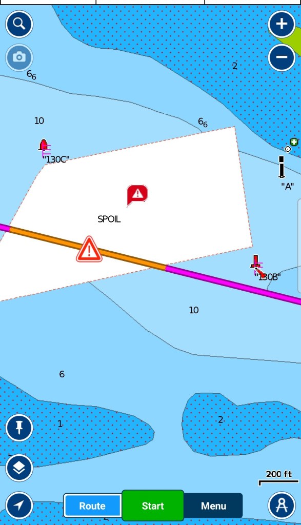
So today I was reading from my old Looping blog in 2018, and determined that the problem Grounding area was Red Marker #132 near Manasquan New Jersey. Then I went to our current Navionics map and found out that the charts have been changed dramatically since I was last here.
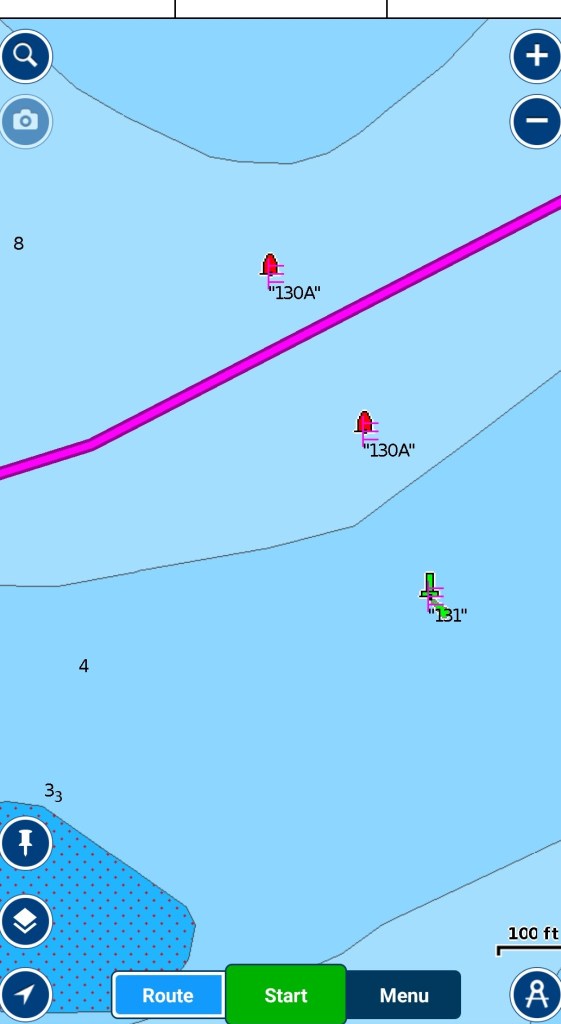
Red Marker #132 no longer exists. It has been replaced with Red Markers # 130, 130A, 130B, 130C
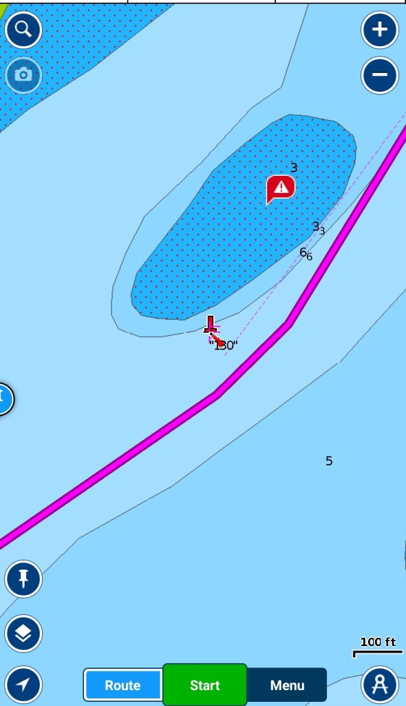
Here is a shot of Red Marker #132 in 2018CY (lower left corner) – The 2 green dots show our boat when we got grounded (left green dot), and after we were towed to true deep water (right green dot). Tow Boat US pulled us thru an area outside of the markers, that the charts said had only 1 ft of water (brown dots). BTW the water is very murky, it’s hard to see the bottom.
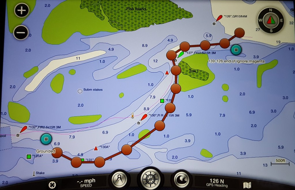
Here are some photos of the current Navionics Chart – Red Marker #132 has been replaced with Red Markers – 130, 130A, 130B, 130C.
There is no longer a marker #132.
So I now have a lot more faith that this area of the NJ-ICW is now correct to the charts, but we will still seek local knowledge from the harbormaster, who is reported to be very knowledgeable on the subject, If we have to stay inside on the ICW.
Issue #1 (Erie Canal Locks #16 & #17) remains our biggest concern.
Thanks for reading !
More to come on this subject during the next slow-day.
Mike, Deena & Jerry

WOW, so much important information to know! I am impressed following this journey with you, Deena and Jerry!
Jan Sherman
LikeLike
Thanks Jan.
I just passed your comments on to Deena. She spoke about her special relationship with you & her introduction to Jerry and job with Dr Kayner.
LikeLike