
Hey Blog Followers,
It’s been a heck of a week.
Gettin’ Looped has conquered the Mighty Mississippi & the Ohio Rivers !
We covered 300 miles in 4 days (whew).
We tied to a barge one night & were on the hook (anchored) 2 nights.
There was limited cell text/call service, but the 2G/3G service did not allow blog updates.
Also the days were very long and we were too whipped to write blog posts.
Therefore, we are now posting the entire week on this one blog update.
We think you will like this post, it’s a doozy !
Tuesday Sept 26 – Grafton to Hoppies Fuel Barge (Kimmswick,Mo).
We traveled from Grafton Harbor to the very Looper famous “Hoppies Fuel Barge”.
The trip was about 56 miles, and included 2 Locks ; Melvin Price & Chain of Rocks.
Hoppies is the last fuel stop on the Ole Miss for 200 miles.
Most of our friend Loopers spent Monday night in Alton Mo, but due to our power cable issue we spent an extra day in Grafton, and left from Grafton Tuesday morning. We left Grafton about 7:30am and kicked Gettin’ Looped into high gear (22mph), and met 9 other Loopers right as they reached the Melvin Price Lock, yippee the lock was open and we could drive right in. All of the bollards were full, but our pals Firestorm (Mike & Laurie) allowed us to raft off of them in the lock. As we entered the lock – holy debris !
The Mississippi is known for lots of debris. We had to steer around a lot of small debris & a large 8 ft log inside of the lock, to raft off of Firestorm.


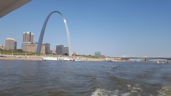
After leaving the Melvin Price Lock, we traveled thru downtown St Louis (farewell Jake & Mollie) and took photos of the Gateway Arch and other Looper boats passing the arch.


After departing St Louis, a 10 boat flotilla led by Gypsies Palace (thanks Steve & Debbie), snaked our way down river between anchored barges, northbound barges/tows coming at us, and southbound barges/tows that we had to pass. All the while under a 4 mph downstream current push. It was both nerve-wracking & an exciting adrenaline rush. This was especially true at the very narrow “Chain of Rocks Canal”, a man-made passage which allows vessels to avoid a very shallow section of the Mississippi.
The very narrow passage made the 10 boat flotilla snake train even more challenging to get around all the tugs & barges.


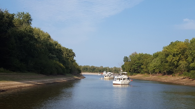
After passing thru the Chain of Rocks Canal & Lock, we were then in the home stretch for the very “Looper Famous Hoppies Fuel Barge”, the last fuel stop for 200 miles.
I must admit that I was a little nervous about the docking at Hoppies. The approach tips are listed as “head upstream into the current, and crab the boat over to the Hoppies Barge”. We made the approach one time to attach to the barge for fuel, and a second time to attach to the barge for our overnight mooring. Both docking events went very smoothly (yippie).
The Hoppies barge is just a very old/rusty set of tied up barges with fuel pumps and power, no water.
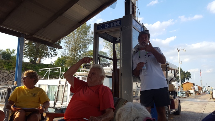
But the Mississippi & Ohio Rivers tutorials from the very famous “Fern” were price-less.


Now safely tied up, I was finally able to experience one of my looper dreams, which was to meet Fern & Hoppie, at the Hoppie’s Barge.
The Hoppie’s fuel barge has been on the Mississippi since 1934, and Fern has been giving advice on how to navigate the rivers since about 1973.
Hoppie is the ole fella & Fern is the ole woman (they reminded me of some of my old Murphree relatives met during my younger years in Mississippi & Alabama).

Fern is a sweet ole woman with a wealth of knowledge. Her advice changed our plans for one of our anchorages, and our path into the Green Turtle Bay Resort (changed from the Tennessee River/Kentucky Lock to the Cumberland River/Barkley Lock (due to high risk of long lock times).
About 10 boats full of Loopers gathered around for Fern’s tutelage, actively taking notes and asking questions.


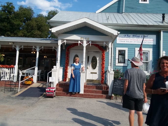
Our second goal at the Hoppies stop, was to visit the famous Blue Owl restaurant in Kimmswick Mo. The Blue Owl is famous for their pies, especially the “Levee High Caramel Apple Pecan Pie”. The owner/operator Mary is a peach, and is also quite famous, having made pies for Paula Dean & Oprah.


That’s about it for Tuesday Sept 26 !
56 miles / 2 Locks / a 10 Vessel Flotilla / Hoppies / the Blue Owl.
Wednesday Sept 27 – Hoppies to Little Diversion River/Canal (Scott County, Mo)
We woke early due to the 110 mile journey from Hoppies to the Little Diversion River anchorage.
Upon leaving Hoppies we had 3 events within the first hour.
Event #1 was seeing the biggest waterway debris that I have ever seen, a floating log which had to be 50 feet long. In the photo below the log looks like a serpent with a body and head, it is actually the same log peeking out of the water in 2 places.

Event #2, a little further downstream, we also noticed a large log which apparently became stuck on the bridge during times of higher water.
Event #3 was the dreaded thump/clunk, followed by a “Loss of Steering”.
After a few seconds of “Oh-Crap”, I put the transmissions into reverse then forward, and the steering returned.
With no locks on the agenda for Wednesday, the voyage was fairly calm other than the “now normal” passing of barges & tows. We arrived at the Little Diversion anchorage about 3:15pm, a 9 hour / 110 mile day. Little Diversion is a drainage river/canal, but in non-rainy times provides Loopers a safe place to stay on the long voyage between Hoppies and Green Turtle Bay. The entrance/exit to Little Diversion is on a large bend in the ole Miss, and current is 4-5mph. Entry is simple via coming in against the current. Exit requires a “Sécurité” call on the vhf radio to make sure there are no tows coming around the blind corner.
We anchored that night with looper friends Mother Ocean (Dennis & Jan) and Thistle (Greg & Reenie), and two other unknown boats.

Thursday Sept 28 – Little Diversion Anchorage to Anchorage @ Mile Marker 948.5
Thursday was a very long /tiring day with about 80 miles to cover, but also 2 locks well known for delays.
The cruise went very nicely, but the lock delays were terrible with 2-3 hour waits. Olmstead lock is a new lock not yet complete, and we had to do a simple drive-thru. The problem was that we had to wait about 60 minutes for the Ok to drive-thru. The next lock #53 is an old lock being replaced by Olmstead. Once inside, the lockmaster directed us to “hover” during the 12 foot drop. It was quite the challenge keeping the boats off the walls due to the high current pushing us to starboard & high wind pushing us aft. Even the boats with thrusters struggled. But all was well after exercising the transmissions for about 45 minutes during the very slow 12 ft drop.
We departed about 7:30am in the morning and arrived at the anchorage at 6:45pm, an 11 hour/15 minute day !
We anchored with ; Mother Ocean, Thistle, and Tyre-Less.
Tyre-Less had arrived earlier due to their higher travel speed, and helped us all negotiate into the 10ft water around the 3-4 foot shoals.
Friday Sept 29 – Anchorage @ MM 948.5 to Green Turtle Bay Marina Resort
New Looper pal Leslie from Tyre-Less awoke at 6:30am to call the lock #52 , ten miles down river (now on the Ohio River). It is usually much easier/faster to get thru the locks if you have multiple pleasure craft, so we agreed the night before to have a 6:45am vhf radio call to find out what the lock #52 said to Leslie about traffic that morning. The lockmaster told Leslie it was a normal day, and go ahead and head down for a potential 8:30am lock-thru.
Check out the sweet sunrise at 6:45am, maybe we should be gettin‘ up at 6:30am every morning (nope !)

We departed about 7:45am for the potential 8:30am locking, a 10 mile ride down river.
After arrival at #52, it was another 1 hour delay, followed by another “hovering” session. The Hovering in #52 was easy, current & wind were lower than the day before at #53.
After exiting #52 we were on our way up the Ohio river to connect to the Cumberland river, and make our way to Green Turtle Bay. The Ohio river, like the Ole Miss, was a very winding route with barges/tows parked in the middle, coming at us, and travelling in the same direction. The barge dodging was now starting to feel like normal business. Following pals Mother Ocean & Thistle, both equipped with AIS and Radar, made the journey easier to know what/who was coming around the next corner. (Note to Self – purchase AIS & Radar if we ever do the river systems again).


After lock #52, Mother Ocean & Thistle spent the night in Paducka, Ky.
Gettin’ Looped went directly to Green Turtle Bay.
This is where todays story gets interesting.
We continued traveling north on the Ohio river to get to the Cumberland river. Recall that Miss Fern recommended taking the Cumberland due to potential long waits at the busy Kentucky lock. The route on the Cumberland was a little longer, but we wished to heed the direction of Miss Fern.
Once on the Cumberland, the complexion of the day changed from all the barge traffic on the Ohio river to a more peaceful/tranquil setting.
We had only one single wide barge and one pleasure boat to pass.
The Cumberland had ; pretty homes, several working plants, rocked walls, several boat launch ramps, and was also a very winding narrow route leading to Lake Barkley & Lake Kentucky.


Just as things seemed like they were finally settling down, and about 2 miles away from the Barkley Lock, THE PORT ENGINE DIED !
After the initial 10 seconds of “oh-shit”, I went down and looked at the hard gauge on the port fuel tank, it was empty.
This occurred, in spite of the accurate digital gauge at the helm reading that I had only used 246 of 290 gallons. But the digital gauge at the helm reads total fuel used between both engines.
I then remembered from all the reading I had done about Gettin’ Looped, that there was a set of fuel manifolds in the engine room that would allow me to pull fuel from the generator fuel tank to the port side engine. After switching the proper fuel valves (closing the port eng tank, opening the draw to generator tank, and closing the generator valve) the port engine fired back up. I knew that after 2 days of anchoring and using the generator, I still had 40 gallons of fuel in the generator tank, so the port engine would now be ok. But, the starboard engine would still be a risk, and unfortunately the starboard hard gauge on the tank had went awol , and the new fuel gauge/sending unit that I installed a month ago in Michigan City was not reading accurately (another long story, not a direct part to part replacement for the original bad gauge).
Bottom Line = the port engine has consistently used more fuel than the starboard, and the actual range of the boat is closer to 250 miles vs the 290 miles I thought I could count on (@ an average of 10-11mph & 1mpg). I have kept good records of speed & fuel usage.
So we now arrive at the Barkley Lock, only 2 miles from Green Turtle Bay. I had called the lockmaster to explain our fuel woes. He tried to get us thru asap, but the wait outside the lock was still about 30 minutes. We used a start/stop strategy on the engines to maintain position between the dam/lock/and bridge, and conserve fuel (anchoring was not allowed).
After what seemed like an eternity, we were finally thru the Barkley lock, and Green Turtle Bay was only 2 miles away.
As we approached Green Turtle Bay, I noticed that the sailing line led to red/green markers about another 1/2 mile ahead of our location. We were in about 18ft of water, I chose an “alternate” entrance to hopefully get to the fuel docks before I potentially lost the starboard engine.
Big Mistake !
Follow your sailing lines & red/green markers !
After looking away from the depth gauge for only a few seconds, the 18 feet of water I remembered was rapidly turning into 8ft/4ft/CRUNCH.
Crap – Grounded.
I attempted to nestle the boat off the bottom, but hearing clank/clank made me stop.
I initiated contact with the marina for potential Tow Boat US assistance, but the Tow Boat was pre-occupied with another grounded vessel request about 20 miles away.
During the call with the marina, I received a vhf call from my new best friend Captain Jim Pyke on Looper vessel “Drift Away” (I wished that I could have drifted away).
Jim asked “are you ok ?”
I responded something like, “yes I am physically ok, but my props may have a different opinion”.
Jim advised “don’t do anything, remain in neutral, I will be right over”.
Jim and wonderful wife Debbie were heading for an anchorage nearby, because they could not get into Green Turtle until Saturday.
They deployed their anchor, unloaded their dinghy, and Jim approached Gettin’ Looped in HIS DINGY ?
Jim said after the fact, that he could see the lack of DINGHY confidence on my face.
Jim asked me to join him on the dinghy with my telescoping boat hook pole.
We circled the boat, using the extension pole to determine which side had the deeper water.
Jim then engaged the front of the dinghy into the bow of Gettin’ Looped and went to WOT on the 15hp outboard. After 5-10 seconds the bow began to rotate around. He then engaged the dinghy into the swim platform and pushed. Within about 1 minute, Gettin’ Looped was back in 6-8 feet of water and able to proceed to the correct entrance to Green Turtle Bay.
After the grounding, we entered the Green Turtle Marina at low speed, so I was not able to determine yet, the level of damage to the props.
On Saturday I scheduled a haul-out for Monday at 1pm.
Today/Sunday, we took Gettin’ Looped out for a low/med/high speed test drive.
Results = No vibration at the helm or at the stuffing box nuts & the stuffing box nuts remain cool under operation.
Mike , you are a lucky guy, FOLLOW YOUR CHARTS !

Obviously Mike & Nellie, treated Jim & Debbie to dinner last night. They are a wonderful couple out of South Carolina, about 8 months into their Loop. Jim had a lot of tips for Mike and our upcoming voyage up the east coast.
A wild week to be sure.
300 miles & 6 Locks in 4 days.
Nervousness, Excitement, Fatigue, Adrenalin Rushes, Meeting more great people !
We are loving this Looping stuff.
So now we can begin to enjoy our stay at Green Turtle Bay Marina & Resort (Grand Rivers, Ky).
The resort has ; Condos, a Yacht Club with Restaurant access for visitors, a Yacht Sales Office, a Ships Store, a Boat Works Marine Service Center (who needs that), 400 Slips, Cable TV at each slip, Tennis Courts, a Beach, 3 Pools (2 outdoor/1 indoor), and a Grill Restaurant.
There are also 2-3 more restaurants in the nearby town, one well-known for their 2″ thick pork chops that we will evaluate later this week.
That’s it for now from Team Gettin’ Looped.
Talk to you in a few days.
Happy Birthday Lauri Scheller !

Sounds like it is turning into a great adventure! Love the blog!
LikeLike
Thx Ryan
Yes it is
Feel like Hick Finn, but with Chartplotter
LikeLike
Great blog, love reading about the adventure. Glad your boat’s ok!
LikeLike
Thx Brian !
Appreciate you following the blog
LikeLike
I am exhausted just reading of your ordeals and escapades and the outstanding progress you are making. Great job!
LikeLike
Thx again Joe,
Little embarrassed for last week’s grounding adventure, but still having a blast.
LikeLike
Glad you are still having fun.
LikeLike
Sharolyn,
It has been a blast
Everyday an adventure
Miss you guys
Can’t wait to see you in Cape Coral
LikeLike
Wow, exciting stuff! You should start building a “Looper Bingo Card” for all the various adventures that can add excitement to the loop… Run out of fuel, run aground, melt a power splitter, get help from a fellow looper, add expensive equipment to your “next loop” list… BINGO!
LikeLike
Shannon,
I love it
A Looper Bingo Card
Maybe I can copy write our new game ( me and you as inventors), and sell the rights to the game to pay our fuel bill or pay for all the dinners for my bride
LikeLike